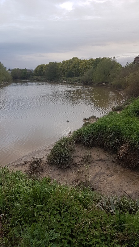
Monday 29th April
 |
| Start of the Llangollen - Looking back down the flight at Hurleston |
Our start on this much lauded canal began with a lovely spring morning, the countryside resplendent in its green, new growth.
We planned a short trip up to the first sizable village of Wrenbury, not very big and only a few miles from Nantwich and Crewe, around the canal, by a hydraulic lift bridge sits the canal basin and the first of the many boat hire points along this popular canal. There are two pubs here and a camping and caravan site along side the towpath.
 |
| Wrenbury basin |
The short trip consisted of 5 miles and 6 locks we had to join a short queue at some of the locks but generally made good progress. The scenery was very pastural, typical of South Cheshire.
We called into the Cotton Arms, a nice spot, dog friendly and good beer.
The following morning we set off heading for Whitchurch a further 10 miles and 10 locks, the first four locks are spread out over a couple of miles before the impressive climb up the Grindley Brook flight, this flight consists of 3 single locks followed by a three chamber staircase. This flight is notorious for long queues, particularly on a Thursday due to the timing of the hire boat changeover days, fortunately for us it was Wednesday and we only met one boat coming down. We were soon at the top passing the pretty tea rooms overlooking the staircase. The staircase is manned and it is important to inform the lock keeper of you presence before starting your passage thorough.
 |
| Grindley Brook locks |
There are good facilities and about half a dozen water points above the locks.
It is only a short trip along to Whitchurch from here, there are moorings just before the lift bridge at the junction of the short arm into the town.
This arm used to lead to a basin just below the town center, one of the main cargos leaving the town was the famous Shropshire Blue cheese made here. Sadly the branch closed in 1939 and some of it has been built over. The short length of the arm now in use was restored by the Whitchurch Waterway Trust (www.witchurchwaterway.uk) and they, along with the town council have ambitious plans to restore the route into the town, including an incline plane to bypass the built over sections, the aim of the project is to increase tourism into the center.
We reversed into the arm along which there are good moorings.
We took a stroll into the town, a typical market town fortunately still retaining a good range of local shops. It is quite a walk from the canal but certainly worth a visit.
Our next port of call was Ellesmere, we decided on an early start setting off in light rain that gradually eased as the day progressed. This is an interesting stretch of canal and is part of the long 20 plus mile pound between locks, the canal twists is way around low hills for the first few miles before crossing the remote and extensive Whixall mosses, an area used for peat extraction but now restored as a nature reserve. The canal crosses the area by means of long straight sections that have proved problematic over the years due to the unstable ground. Evidence of this can be seen by the extensive pilings on either side.
We passed the short Prees arm leading down to Whixall marina and it was here that we came across an episode of boat rage, we had just, slowly, passed a moored, fibreglass boat, as a narrowboat came out of the branch turning up towards us. He was moving quite fast in our direction giving me little time to get over to the side, even though I managed to leave plenty of room he wanted the centre of the canal and gave me a mouthful, I suggested he got a grip, and moved on giving him a large grin which only seemed to exasperate him further.
Between here and Ellesmere the scenery just got better and better, again twisting through the countryside with cuttings and embankments around every corner.
The approach to the town leads through Norh Shropshire's own Lake District, the canal passing close to the shore of several meres. This area is also heavily wooded, adding to its charm.

 |
| Blake Mere near Ellesmere |
There is a short arm leading into Ellesmere, with 72 hour mooring along its length, we sailed to the end of the arm and turned round to moor just beyond the large and useful Tesco store.
Ellesmere is a charming little place with all facilities to hand. We visited the famous Vermeudens delicatessen, a must when in the town, the cheese, pies etc are some of the best we have come across on our travels.
 |
| Ellesmere Basin |
 | ||
| Ellesmere |

 |
| The large CRT base at Ellesmere |
The following morning we moved on heading for Chirk and the Welsh Hills that had provided a backdrop to our journey over the last few days. A few miles along we arrived at Frankton junction where the Montgomery canals drops away to the south we carried along saving our visit to the "Monty" for another day. The approach to Chirk is marked by a narrowing of the channel with substantial concrete banks enabling the canal to cling to the steep sides of the valley containing the river Ceiriog, marking the border between England and Wales. The A5 crosses the valley here on an impressive, modern viaduct, the road now bypassing the town.
 |
| The A5 viaduct on the outside of Chirk |
Mooring at Chirk bank we walked the mile or so into the town.Telford's A5 passed through here leading to the building of coaching inns and some other fine looking properties in the centre. The town now consists of a large woodchip board and Cadbury factory, otherwise it is very quiet.
We walked down to the canal at the southern portal of Chirk tunnel before crossing back into England over the valley on Jessup's fine stone aqueduct.
 |
| Chirk Aqueduct |

 |
Chirk Tunnel |
This stretch marks the beginning of the most famous part of this canal, with two aqueducts and two tunnels within the latest ten miles to the terminus.
We began our journey to the terminus on a cold, windy but bright sunny Saturday morning, we quickly came to the Chirk aqueduct crossing the valley before plunging into the tunnel. Passage through was difficult due to the flow of water coming in the opposite direction, something we had noticed through some of the bridges and narrower sections further back. We finally emerged into a deep cutting, passing the busy marina and hire base.
We began our journey to the terminus on a cold, windy but bright sunny Saturday morning, we quickly came to the Chirk aqueduct crossing the valley before plunging into the tunnel. Passage through was difficult due to the flow of water coming in the opposite direction, something we had noticed through some of the bridges and narrower sections further back. We finally emerged into a deep cutting, passing the busy marina and hire base.
 |
| Chirk Cutting |
Leaving the cutting behind we found ourselves again clinging to the side of a valley, reuniting us with the river Dee, it was here that we got our first glimpse of one of the seven wonders of the waterways. We arrived at the village of Froncysyllte very popular and busy spot, we had to queue here to pass under the lift bridge.
 |
| First glimpse of the iconic aqueduct |
Leaving the village the canal takes a sharp right turn heading straight towards the steep valley side and the famous Pontcysyllte aqueduct.
The approach to the narrow iron channel is through a heavilly wooded section before suddenly to our left there was nothing other than the side of the trough between us and the few hundred feet drop to the valley below. It really was an exhilarating experience, to the one side is the drop, to the other a towpath, very busy with visitors from all over the world marveling at what is an amazing feat of civil engineering. As we reached the midway point the wind picked up banging the boat against the side of the trough.
The approach to the narrow iron channel is through a heavilly wooded section before suddenly to our left there was nothing other than the side of the trough between us and the few hundred feet drop to the valley below. It really was an exhilarating experience, to the one side is the drop, to the other a towpath, very busy with visitors from all over the world marveling at what is an amazing feat of civil engineering. As we reached the midway point the wind picked up banging the boat against the side of the trough.


 |
| Pontcysyllte Aqueduct |
The design of the structure is usually attributed to Telford, however it was a joint effort with Jessup, Telford solved the problem of the weight of such a tall stone structure by using the iron trunk method, resulting in the slender tall pillars striding across the valley.
Reaching the other side, we arrived at the very busy basin at Trevor, our route took us round a very sharp left turn made all the more difficult by the number of spectators and a strong wind, taking it very slowly we completed the manoeuvre and continued our trip to the terminus at Llangollen.
Reaching the other side, we arrived at the very busy basin at Trevor, our route took us round a very sharp left turn made all the more difficult by the number of spectators and a strong wind, taking it very slowly we completed the manoeuvre and continued our trip to the terminus at Llangollen.
 |
| The sharp turn at Trevor |
There are warnings about this section been difficult and shallow before becoming very narrow on the approach to the town. The shallow sections are down to a concrete shelf close to the towpath side, once aware of this it was a case of keeping to the centre of the channel with care required when passing boats coming in the opposite direction, we got through these areas unscathed before arriving at the narrow sections. These are clearly marked, Lucia walked ahead with the walkie talkie keeping watch for anything coming in the other direction. Luckily for us and the two boats following, our way through was clear right through.
Emerging from the narrows we arrived at the town wharf, a very busy place with horse drawn boats taking people to the end of the channel as well as trip boats headed for the aqueduct.
Just beyond the Wharf is the limit of navigation and a large basin, overlooked by the Eisteddfod pavilion, providing 48 hour moorings. These are good moorings and are charged at £6 per night, this includes water and electricity. We secured the boat before heading off to explore.
The town was incredibly busy with its steam railway, boat and bus trips. It came as a bit of a shock as we hadn't been anywhere as busy since leaving Chester.
 |
| Llangollen Basin |

 |
| The gauging house and the canal feed |
It is a lovely town despite the crowds (it was the weekend), there are lots of shops, the type you would expect in a place such as this and it seems to be an ideal centre for exploring the wider area.
We were joined by John Lockwood on the Sunday he kindly brought our mail across with him. John and I walked to the end of the channel, up to Horseshoe falls, so named due to Telford's huge horse shoe shaped weir that directs water into the channel to feed the canal from the river, only to return some of it back in Chester.
This feed explains the flow in the canal we had encountered on our way up from Hurleston, the river not only feeds the canal but also feeds water to the reservoir by the junction which in turn provides water for the people of Crewe and Nantwich.
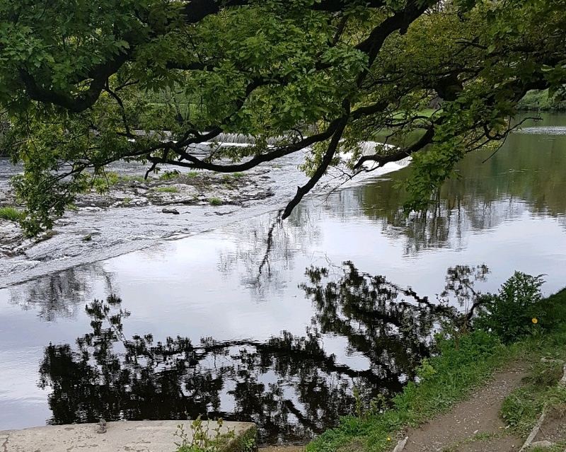 |
| Horseshoe Falls - Telfords large feeder weir |
Care is required at many of the locks as this flow feeds through the by-washes making entry and exit a bit tricky.
 |
| A typical by-wash with high flow |
There is a valve house at the feed, now controlled automatically, responding to the demands of the system.
We enjoyed a fine evening in the Gales Hotel where we had a great meal, it is a peaceful haven in a hectic place with great food, it is more of a wine bar, they only stocked bottled beers, not a problem for us.
Monday morning and it was time to retrace our steps back to Chirk, John had left his car at the RAFA club in Llangollen, they are happy to let you do this for a small donation. We had already determined that there were buses between the two towns so John left use here, returning to collect his car before heading home.
Tuesday morning arrived and we headed back to Frankton junction, having booked out passage on to the Montgomery canal, booking is required as they only allow twelve boats at a time, onto the restored section.
 |
| The locks at Frankton - the start of the "Monty" |

The weather had deteriorated over night and we awoke to heavy rain, thankfully this subsided a little as we made our way to the 4 lock flight to drop down onto the Monty. This section is six miles but originally went all the way down to Newtown, via Welshpool, some 33 miles into Wales. A lot of this canal has been restored but there are a few difficult miles to link the first six miles to the rest of the canal. Much work has been done and still continues so one day the whole length should be navigable again.
 |
| The A5 crossing the "Monty" |
The weather was miserable for most of our trip down to the village of Maesbury but dried up a little once we arrived, care has to be taken along this canal as there are rare plant species so speed limits are in place through several sections.
Following dinner we went into the Navigation Inn and had a great night chatting to the very friendly locals.
 |
| The Navigation at Maesbury |
The village is only a couple of miles from Oswestry and there is a bus service, unfortunately we had to leave the next morning so didn't have time to explore the area.
We made our way back to the junction in more rain but once we arrived at the locks the weather started to improve and we then continued onto Ellesmere where I had arranged to meet a customer to pick up a bit of work.
We stayed in the town for a couple of days before making our way back to the Shropshire Union and the next stage of our adventure.
We enjoyed our couple of weeks on this canal, it lives up to its reputation, and any boaters wondering about a trip to the terminus, don't be put off by the rumours, yes it's busy with lots of hire boaters from all over the world but is great meeting these people, yes it's shallow in a few places but no more than other canals, the countryside along its length and the excitement of the last section make it worth the effort.
 |
| Back at the top of Hurleston locks ready to drop onto the Shropshire Union The grey hills in the distance are the Derbyshire Dales, we shall be on this ridge when we reach the Macclesfield Canal |
 |
| The feed into Hurleston reservoir |
 |
| The gentle rolling hills near Ellesmere |